Welcome to Ej-hiking
Keep your hiking memory
with animated picture
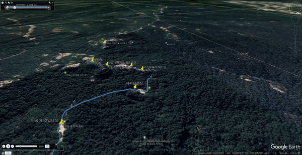
Generate dynamic KML files that visually represent hiking paths through animation.
you just add some pictures into gpx track. Enjoy fully animated pictures with track
Just some picture, gpx file that is all need
IOS support Gpsimgdirection in picture by native camera app, in android you can use opencamera app If GPSimgdirection support , pictures displayed same direction that is same when you taken a picture
Calculate peak position , Google earth camera is heading to peak
When you take a picture during hiking, it is easy to memory when you taken picture , also easy who with you
It's free for the time being.
GPX file , some JPG files
GPX , jpg file upload and insert description each jpg
Just Generate KML , and download kml file
Just open it in GoogleEarthPro, and then play it
EJ-Hiking has completely transformed how I document my hiking adventures. The ability to create KML files with custom animations and metadata is a game-changer. It's so easy to use, and now I can relive my trips on Google Earth with all the details perfectly organized!

As someone who loves exploring trails and capturing moments through photography, EJ-Hiking is exactly what I needed. The seamless integration of GPS data with my photos and the customizable options for titles and animations make this tool a must-have for any adventurer!

Diese App hat mein Wandererlebnis revolutioniert! Mit den benutzerfreundlichen Funktionen und der KML-Erstellung ist es so einfach, meine Reisen zu planen und zu teilen. Absolut empfehlenswert!
Cette application a transformé ma façon de faire de la randonnée ! Les outils simples et la génération KML facilitent grandement la planification et le partage de mes aventures. Je la recommande vivement !
这个应用彻底改变了我的徒步体验!简单易用的功能和KML生成让规划和分享我的旅行变得如此轻松。强烈推荐!
このアプリは私のハイキング体験を一変させました!使いやすい機能とKML生成のおかげで、旅の計画や共有がとても簡単です。ぜひおすすめします!